Rising waters | Rooted solutions
Flood resilience is about systems, not single solutions
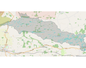
Take a closer look at how our modelling works across different spatial scales, what each scale helps us understand, and how they fit together as part of a single, joined up evidence base.
Flood resilience is rarely achieved by a single action in a single place. It is built across landscapes, over time, through combinations of interventions that work together at different scales - upstream and downstream, natural and engineered, strategic and local.
Understanding how those scales connect is central to how Ousewem approaches natural flood management (NFM) across the Swale, Ure, Nidd and Upper Ouse (SUNO) catchments.
This blog takes a closer look at how our modelling works across different spatial scales, what each scale helps us understand, and how they fit together as part of a single, joined‑up evidence base. It complements our March blog on modelling by focusing on how systems thinking supports better flood-risk decisions in practice.
Whole‑catchment scale: setting realistic expectations
Ousewem’s whole-system model for the SUNO catchment provides something we have not had before: a realistic baseline for what natural flood management may achieve when delivered at scale across an entire catchment.
It helps us understand where the greatest opportunities may lie, and where limits are likely to appear as the evidence develops. That clarity matters because it allows effort, partnership and future investment to be directed where they are most likely to make a meaningful difference.
Basin scale: targeting where effort delivers most
Before developing the full SUNO catchment model, our technical team worked with basin‑scale models for the Swale, Ure, Nidd and Upper Ouse. Using more than 800 simulations, the team developed the hydrological appraisal tool (HAT) - a practical way for delivery teams to explore modelling outputs without specialist software.
Used alongside local stakeholder engagement, HAT helped inform where Ousewem focused its delivery effort, and where NFM was most likely to be effective. Crucially, the modelling does not replace local understanding. Physical characteristics such as shallow soils, geology or geohazards can limit what is feasible on the ground, even where models indicate potential benefit. Basin-scale modelling helps narrow the focus; local knowledge confirms what is realistic.
Project scale: from evidence to intervention
At the project scale, modelling and tools support the practical design of interventions on the ground. They help answer questions such as what type of feature is appropriate, how interventions might work together along a watercourse, and how designs can be adapted to local conditions.
This ensures that NFM delivery is proportionate, technically sound and context‑specific - shaped by evidence but grounded in real landscapes and real land-management decisions.
Community scale: understanding the benefits
Ousewem is now beginning a new phase of work to understand the benefits of the NFM delivered through the project. By focusing on small upstream catchments close to communities at risk, we can explore impacts in much greater detail.
Community-scale models allow us to look closely at individual features - even entering information such as pond depths - to build our most detailed picture yet of how NFM delivery contributes to reducing flood risk locally. This work helps communities, landowners and practitioners better understand how interventions interact and what they are expected to achieve together.
Why scale matters
These different levels of modelling are not separate exercises. They are connected stages in a single evidence‑building process.
- Whole-catchment modelling shows what is possible at landscape scale.
- Basin-scale modelling helps identify where targeted action will have most effect.
- Community-scale modelling helps us understand the benefits of interventions in specific places.
Together, they reflect an important principle: NFM solutions cannot be replicated wholesale from one place to another. Geography, land use, hydrology and the voluntary choices of land managers all shape what can be achieved.
As Ousewem project manager Victoria Murray explains:
“Each scale of modelling asks a different question. The whole catchment model asks what’s possible. Basin-scale work asks where effort will have most effect. And at community scale, we’re asking what benefit interventions deliver in this specific place. The modelling doesn’t give a single answer – it gives us the right questions to ask at each stage, and that’s what good decisions are built on.”
Building confidence for the decisions ahead
The value of this layered approach is not just technical. It builds confidence - confidence that decisions about flood resilience are grounded in evidence, shaped by context, and clear about what NFM can and cannot achieve.
Natural flood management is not a single solution to flood risk. But when it is supported by robust modelling, strong partnerships and realistic expectations, it becomes a credible and proportionate part of long‑term catchment resilience.
This systems‑based approach helps ensure that confidence rests on evidence and learning, not assumptions - and that future decisions are made with a clear understanding of scale, context and impact.