Rising waters | Rooted solutions
Evolving modelling in Ousewem: our journey of innovation continues

As Ousewem has moved from research into real-world delivery, our use of modelling has evolved, refining which tools provide the most value at different stages of the process.
Ousewem’s journey of innovation in hydrological and hydraulic modelling continues! Our approach to natural flood management (NFM) has always been informed by modelling, helping to understand flood risk, design effective interventions, and ensure funding is targeted where it delivers the greatest benefits. As the project has moved from research into real-world delivery, our use of modelling has evolved, refining which tools provide the most value at different stages of the process.
For policymakers and investors, this demonstrates how NFM interventions are now underpinned by a refined, evidence-based approach that balances modelling with stakeholder-led decision-making. For farmers and communities, it highlights how modelling can directly support the design of practical, locally relevant solutions to flooding.
Broadscale and detailed modelling: a complementary approach
Ousewem has used both broadscale and detailed modelling, each playing a different role in shaping NFM interventions.
Broadscale modelling: a catchment-wide view
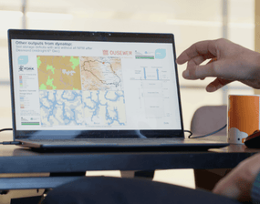
Broadscale models, such as JFlow and Dynatop, provide a high-level picture of flood risks across the entire Yorkshire Ouse catchment, covering over 3,300 km². The models simulate rainfall, land use, and terrain at a regional scale, helping to:
- identify flood pathways across large watersheds
- test different NFM scenarios, such as woodland planting or floodplain reconnection
- provide a cost-effective overview to target further investigations
However, broadscale models have limitations. Their generalised inputs mean they lack fine detail, so they are less useful for designing site-specific interventions.
Detailed modelling: local precision for targeted action
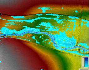
In contrast, detailed modelling (for example, the use of HEC-RAS) focuses on specific locations, incorporating high-resolution data on topography, soils, and land use. This approach is crucial for:
- understanding local runoff pathways and small-scale flood risks
- refining NFM interventions, such as where to create wetlands or leaky dams
- validating the effectiveness of proposed measures before implementation
While detailed models offer greater accuracy, they are resource-intensive and not suitable for rapid, large-scale assessments.
How these tools inform each other
Rather than seeing these modelling approaches in isolation, they work together:
- Broadscale models provide the initial catchment-wide insights, identifying areas where NFM could be beneficial.
- More detailed modelling refines these insights, testing how interventions work at a local scale.
What’s changed? A shift to stakeholder-led decision-making
In Ousewem’s early phases, models were expected to directly identify priority catchments for NFM interventions as well as the interventions themselves. However, in practice, this process has been driven by stakeholders rather than model outputs. This is because:
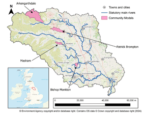
- constraints in certain areas, such as national parks and protected landscapes, cannot always be effectively modelled. This means stakeholder input is crucial in prioritising interventions in these locations
- while models provide valuable predictions, real-world flood events sometimes behave differently due to factors not captured in simulations, such as unexpected land use changes or micro-scale hydrological processes
- broadscale models not accurately representing flood mechanisms at a community levels, for example, in some areas, models indicated potential flood risk despite no previous flooding history. As a result, stakeholders may be hesitant to support interventions, highlighting the challenge of gaining community buy-in when model projections conflict with local experience
- stakeholder priorities and landowner preferences can significantly influence intervention choices. Factors such as existing land use, agricultural productivity, and statutory landscape often shape decisions, underscoring the importance of balancing modelling insights with local knowledge and practical needs
Modelling still plays a key role, but it is now used more to support and validate decisions. As Ousewem continues its journey, we will continue to refine how to best balance modelling and stakeholder expertise. Modelling is also being used to develop a legacy for the catchment after Ousewem, allowing us to prioritise areas in the catchment that are of interest to stakeholders.
Why this matters for policy and investment
Even as stakeholder input has taken a leading role, modelling remains central to Ousewem’s long-term impact. The project has contributed to:
- national advancements in understanding the benefits of NFM without the need for modelling – one of Ousewem’s tools has been adopted by the Environment Agency for further refinement
- better targeting of NFM funding, ensuring investments are backed by evidence
- a scalable model for future projects, demonstrating how NFM can be effectively planned and implemented across different landscapes
Ousewem’s role in shaping these processes has been recognised in the Flood and Coastal Innovation Programme (FCIP) mid-term report, highlighting:
- the development of key modelling tools to inform wider NFM strategies
- a structured grant payment mechanism, ensuring that funding is efficiently distributed for maximum impact
The legacy of Ousewem’s modelling work
The modelling work developed within Ousewem remains vital for the future of NFM in North Yorkshire and beyond. It is continuing to evolve for future applications beyond this project. This future modelling is expected to:
- support broader catchment-scale decision-making across North Yorkshire
- inform policy discussions on how NFM can be scaled across the UK
- enhance understanding of the long-term effectiveness of interventions
For policymakers and investors, it demonstrates a refined and scalable approach to funding and delivering NFM. For farmers and communities, this evolution in modelling means future interventions will be more tailored, effective and grounded in both science and local knowledge.
By bringing together modelling, stakeholder engagement, and practical implementation, Ousewem is not just delivering flood resilience today it is shaping the future of NFM in North Yorkshire and beyond.
To see how these tools have evolved in practice, watch the latest video in our Ousewem series, NFM tools: modelling, theory and practice, highlighting the sophisticated modelling tools we use, and demonstrating their practical applications.